POST, GUNS AND WHALES
South Australia's first known shipwreck.
During a severe storm on 8 December 1837, characterised by a wild south-easterly gale, the barque South Australian was violently ripped from its mooring and blown on to Black Reef, Rosetta Harbor, South Australia, which it struck stern first.
The barque, a South Australian Company vessel, had been at anchor awaiting the arrival of another of the company’s ships, Solway. Once it had hit Black Reef, South Australian was pushed over into the shallow water beyond, close to the shores of what is Victor Harbor today.
Interestingly, Solway wrecked close to South Australian two weeks later. Colonel William Light, the first Surveyor-General of “the British Province of South Australia” briefly surveyed the location, which at the time was a small community primarily involved in the whaling industry, and remarked on his chart that:
“This anchorage, I think, is not fit for anything.”
Image: Extract from “Chart of the anchorages in Encounter Bay” by Colonel William Light, showing the shipwrecks of “S. Australian on Shore”, “Pirie on Shore” and “Solway on Shore”. Courtesy of State Library of South Australia
THE MAIL RUN
Life began as a postal packet
Marquess of Salisbury was laid down in 1817 at Little Falmouth (Flushing), United Kingdom by shipbuilder Richard Symons and the vessel was ready two years later. 236 tons, overall length 26.5m, beam 7.6m and draught of 1.8m. It served as a postal packet for 6 years. In 1824, it was bought by the Royal Navy, converted and renamed HMS Swallow which it remained until 1836 when it was sold to the South Australian Company. The Company was a commercial enterprise formed in London in 1835 which contributed greatly in forming the settlement which was to become the State of South Australia.
In the hands of the Company, HMS Swallow was once more refitted and renamed South Australian – now a colonisation vessel destined to assist in building the new settlement of South Australia. On its international voyage it carried skilled labourers and breeding stock including bulls, heifers, pigs, and goats. Among the passengers was David McLaren who would go on to become the Company’s colonial manager and after whom the famous wine producing region of the State, McLaren Vale, may be named.
Once it arrived in Australia, South Australian worked between Kangaroo Island and Rosetta Bay, resupplying the whaling stations on the shore which could not be reached in any other way but by ship. It was, for a time, refitted as a ‘cutting in’ vessel, which is essentially an offshore whale oil processing platform, but did go on to make one more return trip to Kangaroo Island before the wrecking event. For the larger story on the life and times of the South Australian, visit the SA History Hub.
Images: Top – “H. M. Packet Marquess of Salisbury, Thomas Baldock Esq.r Commander 1822.”, N. Cammillierie, packet portrait, courtesy Bruce Castle Museum. With thanks to Tony Palwyn, Head of the Bartlett Maritime Research Centre, National Maritime Museum Cornwall; Bottom – “View of the South Australian Company’s fishing station and Cape Rosetta, Encounter Bay 1837″ by Col. William Light, watercolour on paper. Courtesy of Art Gallery of South Australia
KEEL BOLTS IN THE SAND
Lost for 180 years. Found 2018.
Finding South Australian
Immediately after the wrecking event, the vessel was salvaged but the lower hold was flooded and nothing could be saved from it. The wreckage of South Australian was abandoned and left to the mercy of the sea.
As time passed, memory faded and the wreck was completely engulfed by the waters. The exact location was slowly and largely forgotten. The knowledge of a wreckage beneath the surface was common only amongst some fishers of the community. Led by the State heritage department, some work was undertaken in the 1990s to locate the wreck site, however efforts did not prove fruitful.
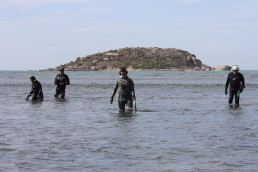
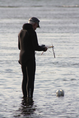
In April 2018, a collaborative project between the Silentworld Foundation, South Australian Maritime Museum, South Australian Department for Environment and Water, Australian National Maritime Museum, MaP Fund and Flinders University, set out to locate the site. Armed with archival information as well as data from previous searches, a magnetometer and several metal detectors, the team walked, snorkeled and dived the area using a survey grid system. The shipwreck was located on the fifth and final day of fieldwork when bright copper bolts were spotted protruding from the sandy bottom.
Follow-up & management
Follow-up work was conducted by the team in May and July 2018 in order to better understand the extent of exposure and type of cultural material on the site. Articulated wooden hull structure as well as some loose artefacts were noted. Biological degradation was evident by the presence of marine borer (shipworm and gribble) tunnels and surface damage of the wood. Another round of fieldwork in June 2019 allowed the team to collect additional data for mapping the wreck site by baseline offset survey as well as digitally in 3D. This visit, almost a year after the last, revealed that the site is “deflating”, meaning that the sediment and sea grass that once covered and protected the site is being naturally eroded away exposing areas of the hull that have remained buried since the time of the wrecking event. This means that loose material is being washed off the site by wave and current action, sometimes this ends up on the beach or is dragged out to deeper water and is lost. The team recovered a small number of fragile items that had become exposed and vulnerable. These are in treatment with the conservation team at Artlab Australia.
These findings were shared by the team with residents of the local community of Victor Harbor during a meeting at Victor Harbor Library in December 2019. The site is managed by the Department for Environment and Water. A 30m fishing exclusion zone was placed on the site to protect the remains of the vessel from physical damage caused by fishing activities and information boards were installed along the beach front and at the nearby boat ramp.
Plans for future work to capture additional data and further protect the site are underway. The project team will keep the local community informed, engaged and involved with the project going forward. Working closely with members of the local area, the team aims to research, interpret and present the stories tied to the State’s first known European shipwreck and the only known shipwreck site of a purpose built postal packet vessel found in the world!
This work forms part of the larger South Australian Immigrant and Labourer Shipwrecks (SAILS) project – a wider undertaking by the consortium to investigate and record the shipwrecks and stories associated with immigration and the transport of labourers, which are of significance in the development of the State of South Australia.
FOLLOW THE STORY OF SOUTH AUSTRALIAN
Updates and insights from the news and our team


